Satellite forest intelligence

Inventory any forest stand from your desk.

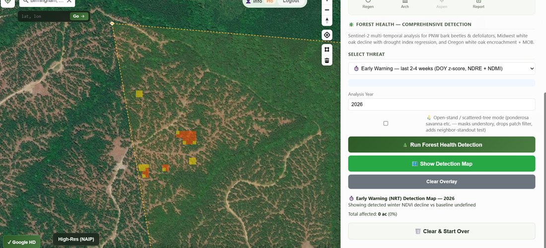
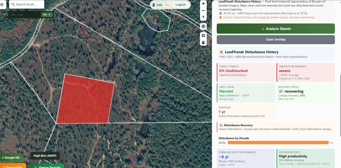
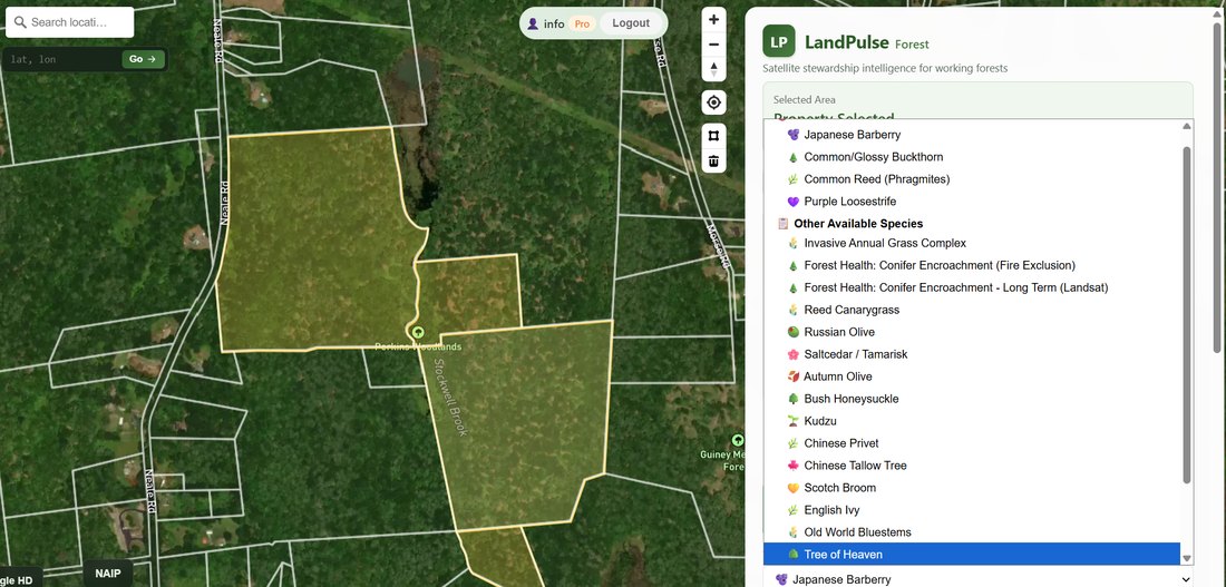
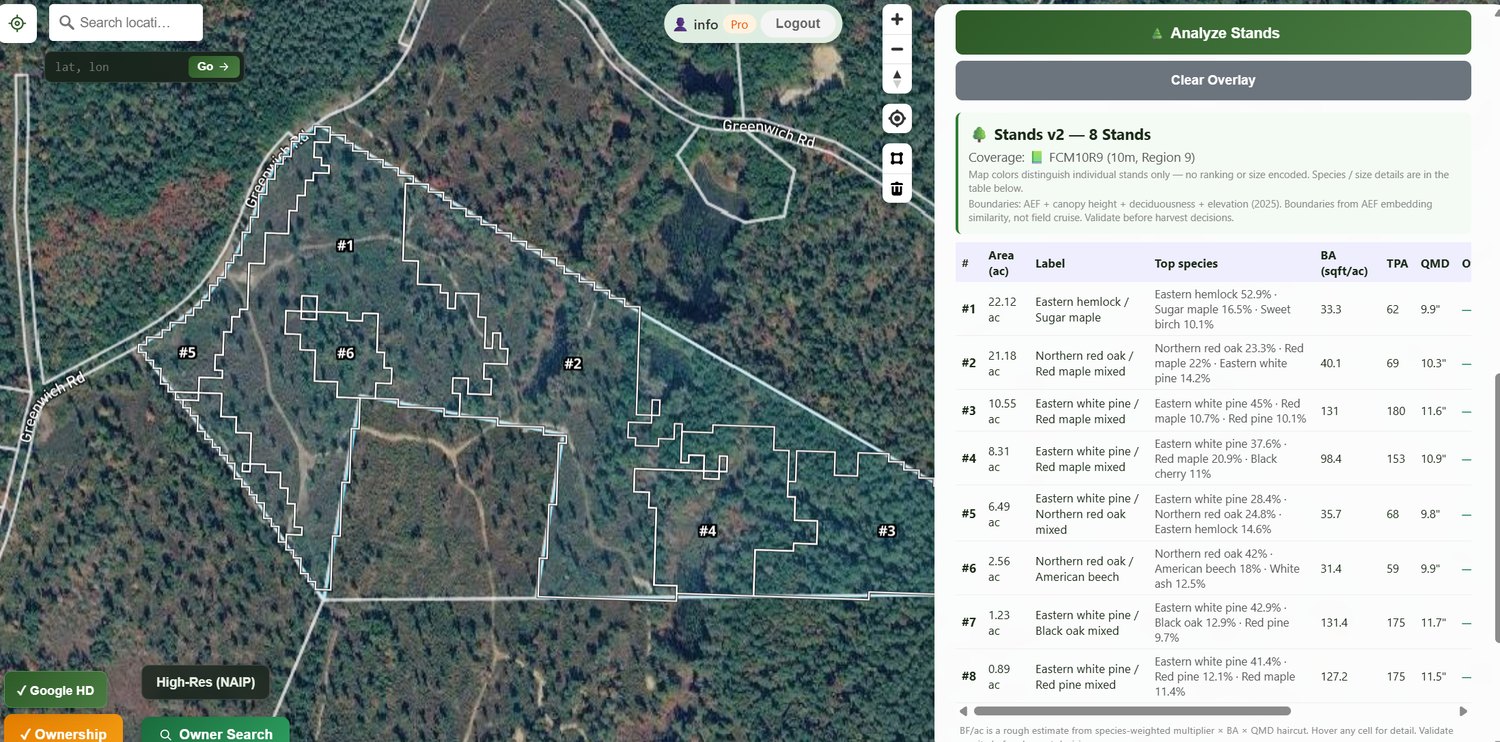
LandPulse turns satellite imagery into stand-level inventory, forest-health detection, wetland mapping, disturbance history, and initial-draft management plans — for any parcel in the continental U.S. An initial read on any stand before you ever leave the truck.

No card required · 5 free analyses every month · Built by a forester.

app.landpulse.net
LandPulse stand inventory — delineated stands on satellite imagery with a forest inventory table
⬇ One click → initial-draft plan (PDF)
Built on Sentinel-2 · 10 m USFS TreeMap + FIA LandTrendr LANDFIRE ESA biomass Meta / ETH canopy height
What it does

Know a property before you stand on it.

Draw a boundary and LandPulse fuses multiple satellite and federal datasets into answers a forester can act on.

Stand inventory & mapping

Automatic stand delineation with the structural numbers that matter most.

  • Basal area, QMD, size class
  • Per-acre volume estimates
  • Forest-type context from TreeMap/FIA, refined with canopy height

Forest health & early warning

Catch mortality and stress before it spreads.

  • Bark beetle, defoliators, oak wilt, HWA
  • Invasives — buckthorn, kudzu & more
  • Near-real-time stress detection

Forest Vision — AI imagery review

A visual second opinion on every stand.

  • AI interprets aerial and stand photos
  • Confirms what looks right, flags what needs a closer look
  • Catches mismatches the models miss before you trust them

Change & disturbance history

Forty years of what happened, and why.

  • LandTrendr disturbance record since 1985
  • Cause attribution: harvest · fire · insect · wind
  • Regeneration tracking on recent openings

Wetland mapping

See the wet ground before you plan around it.

  • Likely wetlands from NWI, water history & radar
  • Seasonal vs. permanent water signals
  • Riparian & hydric context for harvest planning

Carbon & ecosystem

Context for baselines and stewardship.

  • Carbon stock & multi-year trajectory
  • Wetland mapping
  • Watershed, ecoregion & habitat context

Initial-draft plans & reporting

From pixels to a first-draft plan in one click.

  • Initial-draft management-plan PDF with stand maps
  • A starting point to refine — not a finished cruise
  • Parcel & ownership lookup built in

Any parcel. Minutes, not weeks.

Nationwide coverage means you can scope ground you've never set foot on — a prospective client's woodlot, a tract across the state, a whole portfolio.

Try it free →
How it works

Three steps, about a minute.

Draw your boundary

Sketch a parcel on the map, upload a shapefile or KML, or search by owner name and pick the tract.

Analyze

LandPulse pulls multi-source satellite and federal data and runs the models — inventory, health, history, carbon — in seconds.

Get your draft

Read stand-by-stand results on screen, then export an initial-draft management plan to refine and hand to a client or landowner.

See it in action

Real analyses, real parcels.

A few looks at LandPulse working — stand delineation, health detection, and 40-year disturbance history.

Who it's for

Built by a forester — for the people who manage land.

Foresters & consultants

Recon before the field day.

Scope stands before you drive out, triage health issues across a property, and turn client plans around in minutes instead of weeks. Cover ground you've never walked.

Landowners

Understand what you own.

See your forest's species, condition, and history; plan a harvest; track its carbon; and document how it changes over time.

Land trusts & conservation

Baseline & monitor.

Build defensible baselines, monitor stewardship across a portfolio, and support easement and grant reporting with repeatable data.

Free during beta

Start free. No card.

Every account gets 5 analyses a month, free — full access to inventory, health, history, carbon, and plan exports. Running more, or want to put a whole portfolio through? Request beta access and we'll lift the cap.

Paid plans arrive after beta — beta users get first look and grandfathered terms.

Questions

Good to know.

What data is LandPulse built on?

Sentinel-2 (10 m optical), USFS TreeMap and FIA plots, LandTrendr time-series, LANDFIRE, ESA biomass, and Meta/ETH canopy-height models — fused per analysis. The right layers are selected automatically for each tool.

How accurate is it — can it replace a ground cruise?

Think of LandPulse as screening- and recon-grade. It's excellent for prioritizing fieldwork, comparing stands, and documenting condition and change. For high-stakes volume on a specific sale, it complements — not replaces — a ground cruise. We're transparent about confidence on every result.

What areas are covered?

The continental United States. Coverage and model fit are strongest in forested regions with good FIA plot density.

Do I need GIS skills?

No. Draw a boundary on the map, upload a shapefile/KML, or search by owner. Results render on screen and export to PDF — no desktop GIS required.

Does it work on my phone?

Yes — LandPulse runs in any modern browser, desktop or mobile.

How does the free plan work?

Create a free account and you get 5 analyses each month at no cost, resetting on the 1st. Need more during the beta? Request access and we'll raise your limit.

Inventory your first stand today.

Free during beta. Draw a boundary, run an analysis, and export a plan in about a minute.